
Maps and rides
Steeped in History, the Hebridean Way stretches 350 kilometres along the length of Scotland’s Outer Hebrides, from Vatersay in the south to the Lewis in the north. Follow Colin Hood from Hike Bike Tours entertaining personal tale of battling the Scottish elements on his bike below.
BY COLIN HOOD
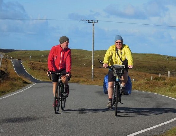
Sandy and I had cycled together across Tibet a few years ago and last year we had cycled through parts of Nepal. Now we were about to tackle the Hebridean Way in my homeland. We had rain, we had wind and we had cold. Sometimes we had all three at once! But you don’t go to Scotland to cycle under blue skies. You go for the scenery and the adventure.
The flight from Glasgow to the island of Barra was scheduled for 1020. However it was raining and the forecast was for a storm to halt services on the morrow. We were worried as we were on a tight schedule. But our little propeller driven Twin Otter 19 seater eventually took off in the turbulence left behind from four massive jets. Seventy five minutes later we landed on the beach. Washed by the tide twice a day, Traigh Mhor beach is the only beach runway in the world handling scheduled airline services. A tractor appeared and took our luggage fifty yards across the beach to the carousel (a wire cage). A taxi appeared, one of only two on the island, and twenty minutes later were at our hostel in Castlebay. We had been lucky! The next day Storm Ali hit the Hebrides with 160kph winds and all ferries and flights were cancelled. So much excitement and we hadn’t even started cycling! We met Tony, our bike man, and amid showers we set up our bikes and panniers. The Hebridean Way stretches 300km north from the island of Vatersay passing through 10 islands linked by a combination of causeways and ferries, over rugged hills and along dazzling Atlantic coastline. The end is the lighthouse at the Butt of Lewis. We had no plan for the next two weeks, just cycle and see where we end up. Because of the storm we decided to stay one more night in Castlebay. But to get used to our bikes, and despite the wind and rain, we decided to nip across to causeway to Vatersay, to the official start point. It was only 12km there and back but it took us three long, wet and windy hours. I have cycled in many places around the world and in many different weathers but the wind on this day was the strongest I have ever cycled in. We had strong headwinds, we had tailwinds, rare but welcome, and at other times it was swirling and gusting from the sides. Add to this some heavy showers and our day perhaps gave us a taste of the adventure to come. The next day we packed our panniers with all our belongings including my laptop (I still had to do some real work), visited the local supermarket and headed out on the main road, the only road. The prevailing wind is westerly to south-westerly. We were cycling north to north-east. Perfect planning! But on the first day cycling out of Castlebay there was some bad behaviour amongst the wind gods. I was half way up the gear cogs cycling up a slight incline but the wind was fighting against me. I am 100kg and I was carrying about 20kg but I was actually forced off my bike just twenty yards from the summit! Although the wind started to behave itself it still took us about two hours to cycle the 15km to the ferry terminal. The seas were angry as we boarded the 1110 ferry. Forty minutes later we arrived on Eriksay where a very steep climb greeted us. I cycled all the way up and at the top, feeling very chuffed, I realised I had left my camera on the ferry. So back downhill I went fighting the massive headwind blowing uphill! I shouted but the crew couldn’t possibly hear. However, lady luck was on my side as the ferry had been delayed for refuelling. I grabbed my precious camera and started the uphill ascent, again, with lungs ready to burst. And this was only the first day and the first few hours!
We were following in the footsteps of Bonnie Prince Charlie who had come ashore here in 1745 on his ill-fated campaign. However we were hoping for a better outcome on our visit! Further up the island is the wreck of the SS Politician which ran aground here in 1941 with 28,000 cases of whisky aboard! Whisky Galore is a book and a film if you have the time! After a beer at the Am Politician pub in memory of all those whisky bottles, we crossed the causeway to the island of South Uist. Cycling across causeways with very strong crosswinds is not easy. It was a challenge trying to stay on the road and not being blown into the ocean. A five kilometre detour saw us at the very remote Glendale hostel. There were only 4 beds and a small kitchen but it was warm and had wifi. Baked beans on toast washed down with a bottle of red wine was a good way to end our first day.
The next day dawned windy and cool. And thankfully no rain! After a cup of tea and a banana we fought our way back to the main road. A few kilometres north, in search of a cooked breakfast, we deviated down to the village of Lochboisdale (ferry to Oban). We could find only one café masquerading as a post office but after a very expensive and succulent bacon and egg roll we cycled back to the main road. South Uist is flat and full of lochs and long lines of sandy beaches backed by dunes and flower-filled machair (Gaelic word meaning fertile plain). The main road runs up the west of the island and is exposed to the Atlantic weather pattern. The east coast is remote, rugged and mountainous. Today we were aiming for the hostel at Howmore, only 40km up the road. However, we were in no rush and the wind was behind us. So we just dawdled along enjoying the solitude and the elements. There was very little traffic and what cars we did see were probably the best behaved and most polite motorists in the world.
Howmore Hostel is a traditional white stone thatched cottage next to the ruins of a 13th Century church. But we had hot showers, a kitchen, free wifi so I could keep up with work and central heating with a cost of just 16 pounds a night! Dinner was simple with a bottle of red wine we had purchased earlier in the day. Next day another island! Our target today was the Nunton House Hostel on the island of Benbecula. Formerly the home of the MacDonalds it was here that Bonnie Prince Charlie, after his defeat at the Battle of Culloden in 1746, dressed as Flora MacDonald’s maid and escaped over the sea to Skye. This was nearly 300 years ago and here we were, not quite following in his footsteps but staying in the same house. I used the free wifi to contact the outside world and I wondered what Charlie would have thought if he could have used it to rally his clans!
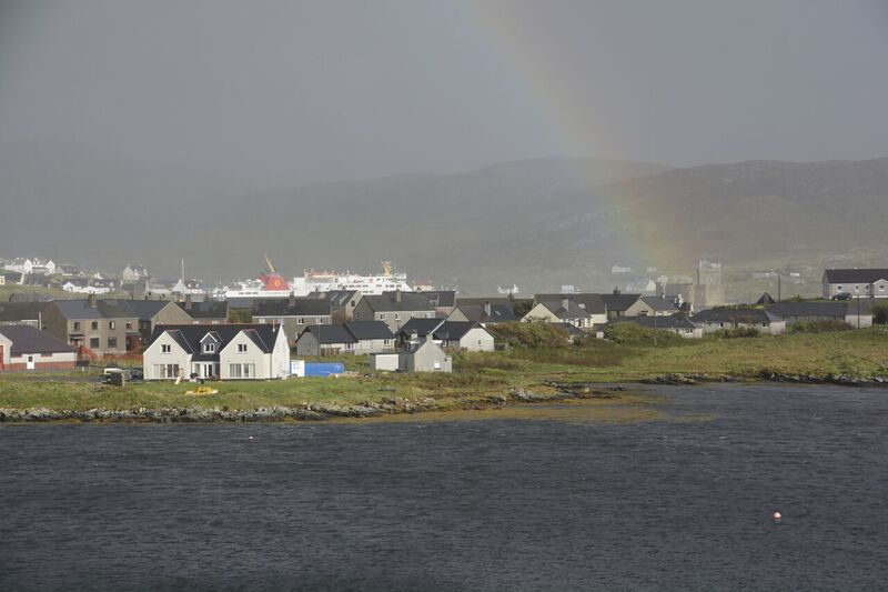
Next morning my two brothers joined us. We had a first cousin once removed and a second cousin living nearby so we joined them for dinner. This was the probably the only time we had been together and maybe the last so we made the most of it. That night we stayed at the Tractor Shed hostel on yet another island, North Uist. Another storm was forecast for the morrow so we cycled to the island of Berneray not sure where we would end up for the day. A circuitous ferry took us to the island of Harris. This was our longest day on the bike so far and we made it to the port town of Tarbert just as it started to rain. We had now left the Catholic part of the island chain and were now entering the domain of the Calvinist ‘free churches’, once described as “the last bastion of Sabbath observance in the UK.” Being heathens, we didn’t notice any difference! The storm hit overnight and cancelled all the ferries. Ali and Graeme had to leave so they took off into a heavily laden sky. We didn’t envy them. Sandy and I however should not have left the hostel. But we did. It was rather miserable as we cycled out of Tarbert and onto a very steep hill. Wind was behind as we pedalled uphill but we didn’t feel the rain. We could see sheets of it skimming along to our right. I was enjoying the pleasure of being blown uphill when, as I neared the top of the hill, I saw the top of the adjacent lochan take off. I knew I was in trouble. I just managed to stop my bike and plant a foot either side when the gust hit me. I have never been blown off my bike and I fought with the handle bars and stayed upright. I had won the battle. We then realised how wet we were. It fact we were saturated. There was a downhill ahead of us, steep, slippy and blustery. We were heading to a hostel. We had only travelled 20km in ninety minutes and we were ready for shelter and a cuppa. The hostel appeared through the rain but it was closed! By now I felt my core cooling and knew we had to get shelter. There wasn’t much around and the rain was relentless. There was a mini bus parked out front. An indication maybe of the hostel being occupied? I checked the front door but it was locked! Whatever plan B was it wasn’t looking good. Sandy checked the back and would you believe it, he found an open door. Heaters were on, dishes were in the sink and the dehumidifier in the drying room was on. But nobody was home. A bit like the Mary Celeste! But what did we care? We put the kettle on and changed into dry clothes. The wet ones we put in the drying room before settling back for the day. We found frozen bread in the freezer so we made some sandwiches with the cheese and tomatoes we were carrying. Washed down with Cup a Soup we were feeling human again. We had survived! My brothers on the other had cycled south back to their van. They had had to fight a fierce headwind and driving rain. But they were fit and made excellent time to the ferry terminal. But the ferry had been cancelled due to heavy seas. Although wet and cold they warmed up and stayed the in the local hostel. I slept well but woke up early. The rain and wind had died down and it was just a normal day on the islands. We left ten quid in the kitchen and took off, warm and fuzzy. The rain gods looked after us as we continued cycling north crossing the divide onto the island of Lewis. We were hungry but the first café was two hours and 30km away. A bacon and egg roll and a cup of tea revived our spirits before we carried on north-east to the settlement of Callanish.
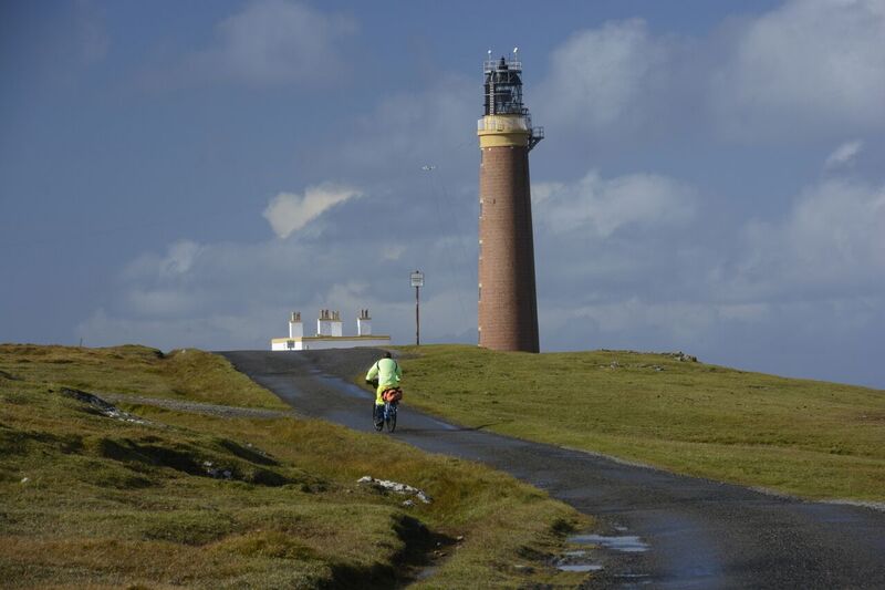
The Callanish Stones are a Neolithic era arrangement of Standing Stones placed in a cruciform pattern with a central stone circle. Same era as Stonehenge but with so many fewer tourists! A few kilometres up the road and via a pint in the local pub we arrived at the Blackhouses of Carloway. The Gearrannan project refurbished this small crofting village made up of several blackhouses which are constructed off double drystone walls with thatched roofs. One of them was a hostel with central heating, hot water and a well-supplied kitchen. Wifi was intermittent but what would you expect on a remote island on the edge of the wild Atlantic? Next day was our penultimate one on the bike. The weather gods were looking after us though. Only one rain squall attacked us but we found cover in a bus shelter. As we reached the village of Port of Ness the sun appeared. Although it was only three kilometres to the Butt of Lewis and the lighthouse marking the end of the Way the wind tried to prevent us reaching our goal. It didn’t work and we made it. We had cycled about 350 kilometres in another remote part of the world.
Hike Bike Tours are in the business of turning travel dreams into reality. An adventurer himself, Colin Hood has drawn from his own experiences to help countless others discover the wonders of bike riding and travel on guided trips through the United Kingdon, Europe, Asia and all around the world. For more information about Hike Bike Tours, see their flyer here, or visit www.hikebiketours.com.au PHOTOS COLIN HOOD
Riding the Hebridean Way
The adventure begins
The ride

The end.
Hike Bike Tours
Have you been on any interesting rides and would like to tell your story? Contact us and send your reports and stories, we’d love to hear them!