
Our Campaigns
On-road bike infrastructure rating tool
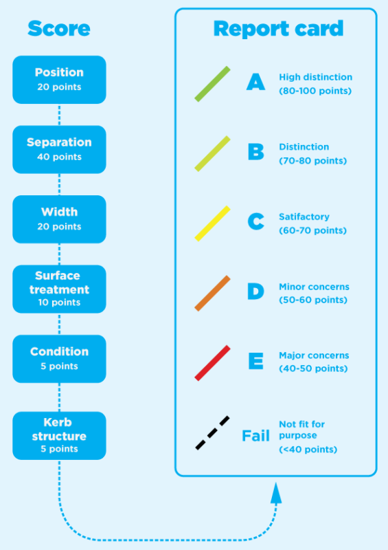
Bicycle Network is proud to introduce the Bike Lane Report Card, our way of rating on-road ‘midblock’ bike infrastructure.
The benefits
- To support and encourage local and state government to build better infrastructure for riders;
- To pinpoint areas of improvement;
- To help riders and non-riders understand the differences between a C grade facility and an E grade facility… or nothing at all!
- To maintain more consistency across what is getting built;
- To show people where the best places to ride are.
How does it work?
There are many ways to rate a bike lane, from connectivity to noise pollution to railway access. The way we grade bike lanes is based on two key elements: safety and comfortability. The grade of a given lane is determined by our scoring system (right), which was developed using a wealth of national and international transport literature (view references). Our goal is not only to get more people riding bikes on the road, but to ensure that they feel safe in doing so.
You can use the map below to explore on-road bike lane infrastructure available around Victoria and Tasmania and find their respective ratings.
In addition to our grading system, you can cast your own grades using the ‘Rate this lane’ link that appears when you select a lane inside the map. Give it a go!
Bike Lane Report CardFAQs
Here are the answers to your most common questions.
If your question isn’t in the list, please contact us via our website or call on 1800 639 634.
Why bother assessing bike lanes?
To spotlight exemplary bike infrastructure across Victoria and elsewhere.
How did you grade the bike lanes?
We used a diverse collection of road design standards, transport research and industry reports in forming our scoring tool. You can review all of our resources here.
What bike lanes have been assessed?
Only on-road (mid-block) lanes will be assessed.
Wait a sec, you missed a bike lane! Why isn't it there?
The map was last updated in February 2022 and Bicycle Network will not be actively updating the map going forward. The Bike Lane Report Card remains a great resource for future updates to bike infrastructure on the road.
Does this mean that quiet roads are rated the same as busy roads?
No. We take into account the speed and congestion of the mid-block space, following Vicroads classifications.
Why are sections of the mid-block lane graded differently?
In many cases, the infrastructure is not consistent across the entire length of the road. For example, St Kilda Road contains protected bike lanes between Alexandra and Linlithgow Avenues, but unprotected painted lanes elsewhere. For this reason, you may observe occasional changes in grade along the same stretch of road.
I frequently ride a bike lane that was graded as a ‘fail’ and I don't agree. Why such a poor score?
That is totally fine to disagree with a grade! We understand that different riders have differing opinions on bike paths, and quite often the bike path with the most riders on it can feel like the safest – regardless of the features.
However, we must consider that bike riding uptake is still low across large sections of our population due to the perceived safety risks. The purpose of this tool is not to be judgmental, but to set a baseline for bike infrastructure best practices that can help us build a more bike-friendly future.
Why are some bike lanes graded so poorly?
Common reasons for a low score:
- Inadequate distance/separation between rider and cars, both parked and on-road
- Inappropriate visibility or marking of lanes
- No separation or boundary infrastructure (concrete blocks, rumble strips)
I've noticed that one of the graded bike lanes is temporarily closed due to road works?
Road works and closures are not considered when grading the lane. Similarly, our map does not provide information on temporary closures or current/future road works.
If you would like information on the status of existing lanes, we recommend checking our newsroom, contacting the local council, or using a transport-based app (e.g. Arevo) that offers information on infrastructure maintenance.
Become our friend
Find out more about Bicycle Network and support us in making it easier for people to ride bikes.