
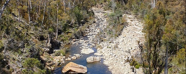
Kingborough Council has released a feasibility study into the prospect of a new 11 km multi-user recreational path following the North West Bay River between Margate and Longley.
The study is open for public comment on the council’s website until 27 July: https://oursay.org/kingborough-council/nwbr-trail
While the council doesn’t have the $1.5 million to build such an extensive track, it’s gauging public support for it before it goes ahead and starts applying for state and federal grants.
The trail would be mostly on the northern side of the river and be available for horse riding, bicycle riding and walking, but not dogs because of the natural values of the area.
Flooding is a common occurrence so any track and bridges would need to be able to cope with the more intense and frequent extreme weather events forecast for coming years. The proposed route is above current known flood levels.
The council would have to gain private landowner permission for some sections of the route and has already had discussions with residents along Riverdale Road who don’t want to see that as an access point.
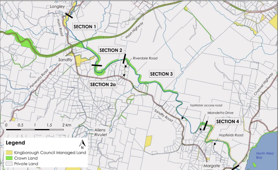
Trailheads could be established at Sandfly Reserve and Longley Reserve but there are no public land options in Margate.
Stages of construction
The report identifies how the track could be built in sections and the cost for each:
- Longley Reserve to Sandfly Reserve: $212,900–$255,800
- Sandfly Reserve to Riverdale Road and link with Allens Rivulet trail: $29,000–$67,000
- Riverdale Road to Miandetta Drive: $418,000-$1,049,000
- Miandetta Drive to Hopfields Road and Margate Bridge: $72,000-$131,000.
The trail would only be 1.2 metres in width, which does not leave a lot of room for passing horses, essentially requiring other users to get off the track. Because of this, the report recommends wider sections for passing where the landscape is open.
It would utilise natural surfaces and materials and be of benched construction, which looks like flattened earth but with retaining walls and drainage where required.
The track would need to cross the river in 6–7 locations across stable rock sections, which would mean the track couldn’t be used during flooding or high water levels.
The costings provided are just for trail construction, they do not include other costs such as trailheads, parking, signs, bridges or ongoing maintenance associated with river crossing flood damage, and weed and dog control.
Cultural and Natural Values
As the track would traverse sections of undisturbed riverside vegetation, there are identified dangers to threatened species by building a track.
For the most part the track would go through common vegetation types and would go around the small sections of threatened vegetation communities.
It would also need to avoid nesting, feeding and denning habitat of species such as the Tasmanian devil, swift parrot, masked owl, wedge-tailed eagle, spotted-tailed quoll, eastern quoll, and grey goshawk.
The intact vegetation is generally free of weeds. Opening up intact areas with a path increases the risk of weed spread, which would mean the council would need to commit to effective weed control after the track is built. The report recommends washdown stations at trailheads to help prevent the spread of weeds.
The catchment is under-surveyed for Aboriginal values, so this would need to be done and the track re-routed to avoid any sites that are discovered.
Because of the abundance of wallabies, bettongs, bandicoots and nearby farm animals, dogs would have to be kept off the track, which again the council would need to commit to policing after the track is built.