
More details have been revealed of the bike infrastructure to be delivered as part of the massive North East Link road and tunnel project.
As previously reported, the project will build and upgrade many vital connections in the north-east vector of the metropolis, where bike infrastructure is currently sparse.
The details were released as part of the Environmental Effects Statement for the multi-billion dollar project.
The ESS assessment can alter, add or subtract facilities. As well, once the tender process is underway, bidders may offer further improvements.
There is a way to go yet, but the project is certain to make key destinations in the north east much more accessible to people riding bikes.
The EES says the current network of shared use paths in the region can be indirect and unsuitable as commuting corridors, and that there were few on-road cycling paths and limited connectivity between activity centres and the exiting cycling network.
"Extensive shared use path upgrades are expected to improve accessibility and travel times for pedestrians and cyclists across the north-east”, according to EES documents.
These include construction of:
- A new shared use path parallel to the above-ground sections of North East Link, completing the missing link in the Greensborough Road corridor
- A new north-south shared use path along Bulleen Road
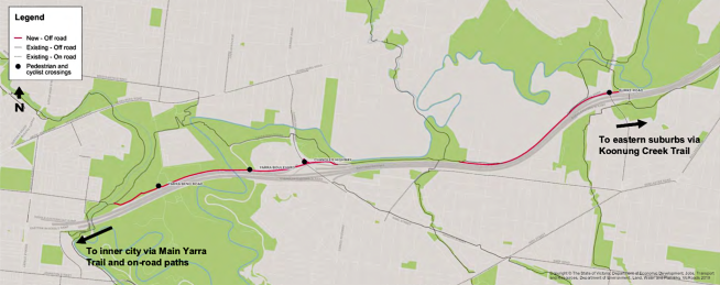
- A new shared use path between the Merri Creek and Chandler Highway, known as the North East Bicycle Corridor.
The new paths will be fully sealed and generally three metres wide, linking existing shared use paths to improve access to the Watsonia and Heidelberg town centres, as well as the community facilities along Bulleen Road. Where practicable, separated footpath and bicycle paths will be provided.
As part of the Eastern Freeway upgrades a new shared use path, the North East Bicycle Corridor, will be constructed between the Merri Creek and Chandler Highway
Its key components include:
- A connection to the Main Yarra Trail near Chandler Highway at the eastern end
- A connection back to the Main Yarra Trail at the Merri Creek crossing near Roseneath Street
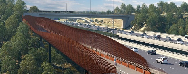
- A new path under Chandler Highway parallel to the Eastern Freeway which will cross over the outbound off-ramp on a new bridge structure, before crossing Yarra Boulevard and Yarra Bend Road at grade.
During construction, the majority of shared use paths would remain open or suitable temporary diversions would be provided. Nevertheless, it is anticipated that construction activities that involve the delivery and installation of concrete beams would require temporary closure and diversion of existing walking and cycling routes.
The urban design strategy for the project says it will emphasise clear visual and movement linkages between streets, footpaths, bicycle paths, and public open spaces, and connect public transport, neighbourhood activity centres and other key community facilities and services.
"Opportunities to remove barriers that discourage walking and cycling, cross-project corridor connectivity, and the community’s ability to reach everyday services and facilities within a 20 minute walk are maximised. These barriers include physical obstructions, and a lack of shade and rest stops.
"Pedestrian and cycle crossings of the project corridor are celebrated and emphasised to encourage greater sense of connectivity.
"Opportunities for grade separation of walking and cycling paths from roads are maximised.
"Separated walking and cycling paths are used in high-use areas where appropriate, and minimise the potential for conflict between intersecting travel paths.
"Wayfinding and signage is used to improve the ability for people to find their way to key destinations."
Become our friend
Find out more about Bicycle Network and support us in making it easier for people to ride bikes.