
Bike riders in the middle suburbs of Melbourne’s south east could at last gain the improved riding environment they have long deserved.
Suburbs in the south-eastern arc, including East St Kilda, Glen Huntley, Ripponlea, Elstenwick, Ormond, Caulfield, Murrumbeena, Carrnegie, McKinnon and Bentleigh, have never generated the rider numbers that local geography and socio-economic factors suggested.
The streets, which can be jammed packed with cars going no-where, should have been thick with bikes taking residents to work, to school and university, to shops and to railway stations.
Such desire has been long thwarted by the lack of an attractive network of bike facilities.
But that could now change.
The City of Glen Eira has just released a draft Integrated Transport Strategy that sets a new direction for transport within the municipality.
The City indicates that it will no longer seek to balance the needs of all modes on all streets, but instead will nominate streets as preferred routes for classes of users.
“By taking a range of external factors into account (including road widths; local area destinations; and existing connection and function) to determine the best and highest use for the limited road space within the municipality."
This means that certain streets will be optimised as key routes for bikes.
"A safe cycling street is a road or street that aims to enable cycling as a legitimate transport mode choice. These streets foster a safe environment for people of all abilities to cycle safely between destinations,” the City says.
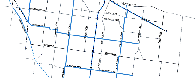
It has nominated the following roads as safe cycling streets:
- Inkerman Road
- Orrong Road
- Bambra Road
- Koornang Road
- Tucker Road
- Nepean Highway
- Riddell Parade
- McKinnon Road
- Thomas Street
Possible improvements may include:
- Construction of separated, safe bike paths
- Ccontinuation of all bike lanes through intersections
- Minimising car movements across bike lanes at traffic signals
- Consistently reduce vehicle speeds along roads
- Ensuring lighting is of a high standard along full length of the streets
- Exploring the reinstatement of lost street parking where required.
The strategy also has plans for streets for public transport, shopping and walking, and driving.
It also has innovative concepts for child-friendly neighbourhoods.
The City says Glen Eira has limited opportunity to increase road capacity, "which means that continuing along the trend of increasing car numbers will ultimately lead to a critical tipping point where car travel is no longer an attractive travel choice."
“Where congestion cannot be improved, the key will be to improve the speed and safety of other modes such as trams, trains, buses, bikes and walking.
“Acknowledging that the continued growth in car trips is unsustainable, Council will to work towards increasing the share of active and sustainable modes such as walking, cycling and public transport."
The council is seeking feedback on the draft strategy. Make your contribution here.
Glen Eira BUG is planning a forum to discuss the strategy. Details will be available soon.
The draft strategy document is available here.
Further information is in the document library on this page.