
The designs for the new 17km Caulfield Dandenong Trail are done and dusted and work will begin in the wake of the nine level crossings removals along the corridor as they roll out from next year.
The trail, which has yet to be formally named, is to be built as part of the 22.5 hectare linear park being delivered with the level crossings removal project.
It will extend from the Caulfield campus of Monash University as far east the Eastlink Trail at Noble Park station.
Because of the decision to use elevated rail and stations in sections of the corridor, the state government seized the opportunity to complete the trail, add new connections to other key bike routes, and enhance neighbourhood facilities along the way.
Bicycle Network participated in the expert panel appointed to seek community input to guide the design of the project.
The trail will be a vital link for riders getting to railway stations, for commuters getting to work and education, and for recreational riders on longer trips.
About 12 km of the trail will be new 3 metre-wide concrete. The rest is existing trail built previously by local councils.
Busy station precincts have posed a challenge for the designers, with the convergence of pedestrians, buses, private cars and bikes into a confined area.
Additional footpaths will be provided in these zones to minimise friction between riders and walkers. Lighting and CCTV will be added at selected locations to enhance security.
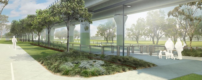
The trail will be greatly enhanced by landscaping, with 30,000 trees and shrubs to be planted, though it may take 20 years for the trees to reach full maturity.
At some locations though, the effect will be marred by the hideous scar of vast car parks installed at the insistence of politicians.
There will be plenty of rest points elsewhere, with bike parking rails, seating, and water fountains.
Bike parking is being provided at all the new stations, with provision for expansion when required.
The trail will be just about the last aspect of the project to be constructed, after the major works are completed.
Further details are available in a fact sheet here.
The report of the expert panel is here.
Detailed aerial maps of the various sections of the trail can be found on this page.