
The amalgamated Canterbury-Bankstown Council is seeking feedback on a Draft Active Transport Action Plan 2020-2030 that aims to provide an interconnected cycling and walking network through the Inner West and South Western region of Sydney.
The plan identifies the priority infrastructure projects that are considered to have the biggest potential to improve active transport for those who live in and pass through the region.
Given the geographically central location of the council region, Canterbury-Bankstown transport infrastructure does not only serve local residents, but also supports the Greater Sydney movement network.
Mayor Khal Asfour said that like many areas across the country, Canterbury-Bankstown Council received a significant spike in requests for more cycleways since the COVID-19 pandemic struck, and says it is now time to act and capitalise on new habits and opportunities.
"The City of Canterbury Bankstown is covered by a network of over 908 kilometres of roads, but car-centric planning and a lack of safe walking and cycling infrastructure has led to a reliance on private vehicles and an increasing amount of traffic congestion across the city.
"As the City continues to grow, this is not sustainable. Council has an ambitious vision to see more people using not only public transport, but also Active Transport as their preferred mode of travel."
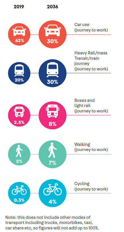
This plan aligns with the Council's 20 year strategic planning statement, Connective City 2036, which set the following targets:
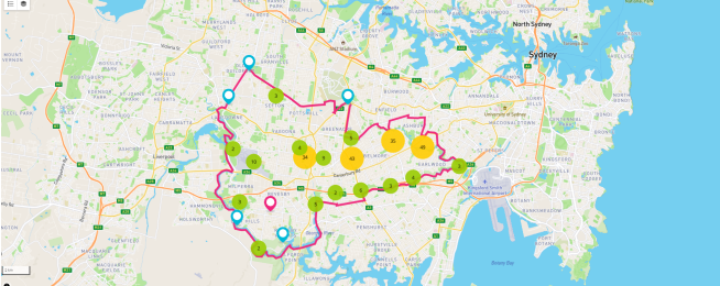
The existing bike riding network is described as being predominantly comprised of off-road shared paths, unevenly distributed across the city, with the quality, suitability and maintenance of the facilities also varying widely. There is also no structured approach to wayfinding, with routes often ending abruptly leaving cyclists to navigate difficult traffic conditions.
The vision for the future bike riding network is not based on simply connecting the the gaps, but rather analysing where people want to go and what is stopping them from doing so on bikes.
![]()
The draft plan identifies 12 key bike riding routes based on connections into neighbouring councils, key destinations across the city, existing infrastracture and providing a broad network coverage.
The plan also takes into consideration changing transport patterns associated with the COVID-19 pandemic, when active transport was brought to the forefront of public consciousness.
Download draft Active Transport Action Plan 2020-2030.
The council is currently seeking feedback via an online submission form, as well as an interactive map where you can add markers and comments.
HAVE YOUR SAYBecome our friend
Find out more about Bicycle Network and support us in making it easier for people to ride bikes.