
After an initial round of community input, Glenorchy City Council has released a masterplan to govern the future of its Mountain Bike Park and trails in the area, including a cycling hub within Tolosa Park.
The MTB Park opened in 2005 and led the state in competitions and tracks available for recreational riders, but since then the largely volunteer-built facilities have fallen behind what riders now expect. Data collection shows the number of bike riders has fallen from 9514 in 2014–15 to 6660 in 2019–20.
The council has used a state government grant to engage well-known MTB specialists Dirt Art to develop a plan for the area to cater to local and visiting riders, with a family-friendly focus.
The main thrust of the plan is to create a new bike riding hub in Tolosa Park which includes:
- realignment of the road racing criterium circuit
- MTB dirt jumps to replace existing jumps
- asphalt MTB pump track for riders to improve skills
- a BMX track built to national event standard
- a clubroom for cycling organisations
- a new café and increased car parking
- trailhad and shelter.
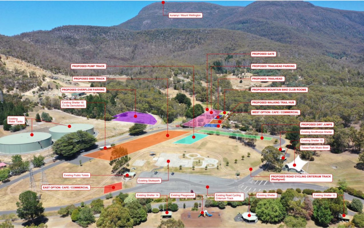
The racing criterium route has caused issues in the past as it involves closing the access road to other users of the park and access to the skate ramp. The proposed realignment would mean the circuit is a closed loop and can operate alongside other park users.
A new BMX track is being proposed a result of the expansion of the Museum of Old and New Art (MONA) onto land currently hosting BMX facilities. The proposed track would be built to a standard which would allow national BMX events to be held at the park, which would be a step up from current facilities.
The existing dirt jumps have been built in a low-lying area subject to flooding and tree falls, moving the jumps would avoid this damage.
Two clubs regularly use the park: Hobart Wheelers–Dirt Devils and the Southern City BMX Club. Both could use any clubroom for meetings, practice sessions and racing and events.
A trailhead and shelter would include bike washdown, trail information and a place for families to rest and would include the option of shop/outlet to provide café and bicycle services.
Some of the new facilities are proposed on land owned by the Glenorchy City Council but currently leased by the Sporting Shooters Association of Australia and Life Without Barriers. The council has talked to both groups, with the shooting range to potentially be relocated to the Mitchell Range but no option put forward for the 12-year-old native plant nursery operated by Life Without Barriers that provides plants to Conservation Volunteers Australia.
Another outstanding question from the plan is Glenorchy Council’s willingness to fund the maintenance a new trail network or a volunteer maintenance program.
New trails
The masterplan proposes 14 new MTB trails to complement the existing network, including 6 km of green beginner, 19 km of blue intermediate and 5 km of black advanced tracks.
It also rates the 15 km of existing tracks and trails, with recommendations to:
- close the North Shore trails area
- redevelop the 4X Track into a dual slalom track and closing the current Dual Slalom Track
- redevelop the Slopes Style Track into an intermediate level jumps track
- convert the upper section of the North–South Track to a single direction, single-use descent
- realign the Gully Loop
- close the Short Downhill Track.
New trails could link up with the new network being proposed by the City of Hobart, to create about 100 km on tracks in Wellington Park, other council-owned land and Cascade Brewery land.
The masterplan also floats the idea of longer “backcountry” trails that could be developed if current water catchments zones are changed, following the closure of two reservoirs. The routes include Glenorchy MTB Park–kunanyi/Mt Wellington summit and lower foothills North–South track ascent.
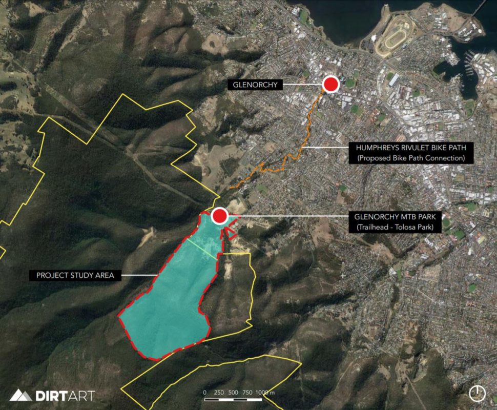
Glenorchy’s city centre and Intercity Cycleway could be accessed by building a shared path alongside Humphrey’s Rivulet, which may help expand the current 9% of users currently accessing the park from local footpaths and roads. Such a path would also service several schools in the area and provide a valuable transport link for local residents wanting quick access to shops and services.
There are three ways for you to have your say: comment on an interactive map, complete the express survey, complete the full survey: https://gcc.mysocialpinpoint.com.au/gmbp