
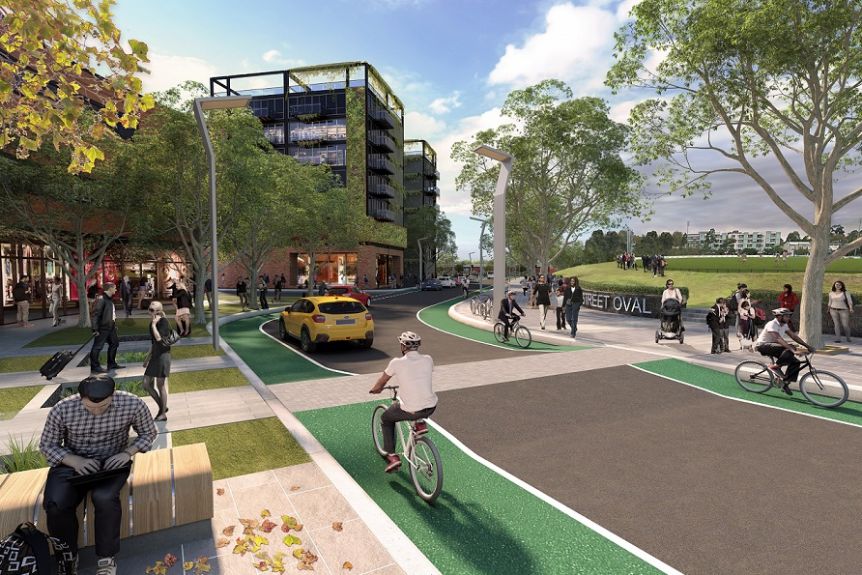
Draft plans for Melbourne’s new high density science-focused inner suburb at Arden have confirmed the district will be car-lite and humming with people on bikes.
The new precinct, spanning West and North Melbourne along the Moonee Ponds Creek, is to be developed in the wake of a new underground railway station now under construction as part of the Melbourne Metro project.
The former largely industrial precinct, adjacent to the North Melbourne football ground, will be transformed into dense, contemporary residential and employment complex at a location close to the CBD and to the Parkville university and research precinct.
Fifteen thousand residents and 34,000 workers will be populate the area when it is completed.
Streets will be free of car parking, and multiple laneways will form a grid across the suburb, ideal for the location of knowledge based industries that benefit from face to face interaction.
The Arden Vision includes targets for all trips to Arden to be 60 per cent public transport, 30 per cent walking and cycling and 10 per cent private vehicles.
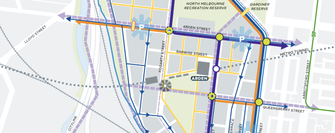
Plans show a group of major bike routes flowing into and through the core of the area, with four Strategic Cycling Corridors converging on the precinct.
Arden Street, Dynon Road and Queensberry Street, and Laurens Street will now connect at the Arden precinct.
Additionally there will be a new route created along the extension of Langford Street, and the Queensberry Street route will be extended through the centre of the precinct as far at the rail corridor.
The Capital City Trail along Moonee Ponds Creek provides regional cycle access to the suburbs of Moonee Valley and Moreland (via Royal Park and the Upfield bike path) and on to Docklands, Footscray and Fishermans Bend.
New cycling infrastructure constructed as part of the West Gate Tunnel project will provide a shared path from CityLink over the Moonee Ponds Creek and the rail corridor to Dryburgh Street.
Improved cycling infrastructure on local streets will address deficiencies such as bike lane gaps at intersections and will be designed to be safe for all users.
The strategy will deliver a dense network of local feeder bike lanes to complement the Strategic Cycling Corridors and provide access for bicycles to destinations within the precinct, including the proposed government primary school, community hubs and innovation hub.
The area will have a transport network that limits vehicle circulation to reduce conflicts between pedestrians, cyclists, public transport services and private vehicle movements.
The Draft Arden Structure Plan states: "The planned density and diversity of land use within Arden provides an excellent opportunity for most local trips to be made by walking, cycling and public transport, and allows for the uptake of recent trends towards small electric transport options such as e-bikes."
Arden’s fully integrated transport network is designed to enable its net-zero carbon objectives.
The low-lying, flood prone area will utilise water management as part of the open space and tree provision.
SEE THE DRAFT PLANBecome our friend
Find out more about Bicycle Network and support us in making it easier for people to ride bikes.