
The massive North East Link road project looks set to deliver Melbourne’s biggest ever boost in bike infrastructure investment.
Plans released this week include an estimated $230M of new active transport routes and upgrades.
The biggest gain is the provision of the eastern bike corridor, a direct commuter route into Melbourne’s inner north from the Chandler Highway along the new Busway on the Eastern Freeway.
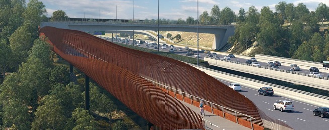
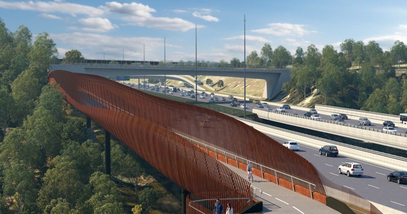
The route requires the construction of a new bridge over the Yarra, as shown in the below artists impression.
A number of other important gaps in the network will be addressed, including the missing link two new Yarra River crossings and completing missing walking and bike riding links play a key role in improving all forms of transport for Melbourne.
As well as enhancements directly included in the North East Link Project, a number of complimentary upgrades will be provided in conjunction with NELP, including upgraded routes to LaTrobe University.
There will also be another new bridge over the Yarra in Heidelberg at the foot of Yarra Street to provide a vital east-west river crossing instead of hostile Banksia Street.
NELP calculates that about 25 km of new and improved routes will come as part of the package.
The upgrades are understood to be included in the reference design for the project that will go to tender after the state election.
The tender process could result in further enhancements proposed by bidders, and the environmental planning process may also result in better facilities for riders
The new route along the Eastern has long been discussed due to the problems with the indirect route along the Yarra River.
As a result of the construction of the Busway along the freeway, the eastern bike corridor can now be delivered.
The designers faced some critical challenges, which appear to be overcome, with underpasses and acceptable gradients.
Upgrades to the Eastern Freeway corridor include:
- A new bicycle path near the Burke Road interchange, to short-cut the existing trail which currently detours around the Burke Road Billabong Reserve
- Path upgrades to the existing Main Yarra Trail between Belford Road and Burke Road, which is generally in poor condition, narrow, and steep in some sections (including bypassing the steep section of Belford Road)
- Replacing all existing footbridges between Bulleen Road and Springvale Road with shared use bridges and a new walking and bike riding bridge at Bulleen Road
- New underpasses at Bulleen Road and Doncaster Road to bypass traffic lights.
A key challenge resolved was the steep climb to Belford Road in Kew. The reference design now includes a new 500-metre bicycle path on the north side of the Eastern Freeway at freeway level (separated by a crash barrier and screen) and under the Belford Road bridge.
There is now also a quicker, more direct route under Burke Road with a more direct route for riders travelling between the east and west by extending the path next to the Doncaster Busway under Burke Road. This new path would be approximately 700 metres shorter than the existing route around Burke Road Billabong, saving bike riders two to three minutes in travel time.
Greensborough Road corridor
The upgrades along this corridor include new paths and crossings over North East Link, including:
- An upgraded walking and bike riding bridge over the M80 Ring Road near Macorna Street, linking into the existing Metropolitan Ring Road path
- A new walking and bike riding path between Macorna Street and Grimshaw Street
- A new, accessible bridge over Yando Street
- Grade separated crossings on both sides of North East Link under Grimshaw Street
- New walking and bike riding paths on the western and eastern sides of North East Link between Grimshaw Street and Watsonia Road
- A new walking and bike riding connection from Elder Street to Watsonia Station
- A new walking and bike riding path between Watsonia Road and Yallambie Road and widening of the existing path between Yallambie Road and Lower Plenty Road
- Three new signalised pedestrian crossings across Greensborough Road, at Drysdale Street, Strathallan Road and Wattle Drive
- A new east-west walking and bike riding path in the reserve north of Drysdale Street - between Greensborough Road and Lower Plenty Road
- A grade separated crossing of Lower Plenty Road to the River Gum Walk trail, removing cyclists from the Lower Plenty Road interchange
- A new bike riding route on Nell Street
- A new walking and bike riding path at Morwell Avenue
- A new Greensborough Road to La Trobe University on-road bike riding route
- A new bike riding route along Lower Plenty Road.
Bulleen and Heidelberg
- A new walking and bike riding bridge across the Yarra connecting Yarra Street and Banksia Park
- A new walking path at the Manningham Road interchange
- This path connects Banksia Park to Bulleen Road.
- A new walking and bike riding path along the eastern side of Bulleen Road between the Manningham Road interchange and Thompsons Road
- Three new signalised crossings across Bulleen Road for pedestrians to safely cross, at the North East Link ramps, the Veneto Club and the Marcellin College access road
- A new walking and bike riding path along Thompsons Road, between Bulleen Road and the Koonung Creek Trail
- A new walking and bike riding bridge on the eastern side of the Bulleen Road overpass at the Eastern Freeway. This will mean safer and easier crossing of the freeway, linking the new Bulleen Road path with the residential areas south of the freeway.