
The City of Port Phillip has signalled a major upgrade to it bike riding network, with eleven bike corridors to be completed in the next 10 years.
Three more corridors will come after 2028.
The top three priority corridors are already committed, either underway or in planning: Moray Street, Kerferd Road, and Albert Road.
Very conveniently, these top priorities are projects being undertaken by the State Government – Melbourne Metro is building Moray Street and the other two are part of the recently announced Shrine to the Sea ceremonial route.
The plans are outlined in the draft Port Phillip Integrated Transport Strategy 2018-2028, out for public comment.
"We need to invest in a dedicated program of infrastructure improvements for bike riders of all abilities if we are to improve bike rider safety and make it an attractive choice for our community,” the strategy says.
"We know the best outcomes are achieved when we deliver bike lanes that are safely separated from pedestrians and vehicles, and for these lanes to be a continuous route between major destinations."
The strategy says bike riding is one of the most efficient ways of moving people in Port Phillip because:
- It is very space efficient, meaning we can move more people through the same space, and when parked needs less space than a car
- The cost to build and operate bike riding facilities is very low compared to public transport and cars
- It provides a healthy and environmentally friendly way of getting around
- Bike riding is a quick means of transport for short to medium length trips
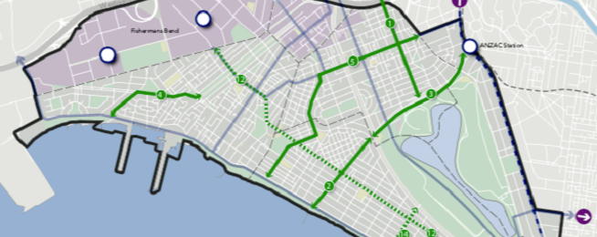
The full list of 14 corridors comprises:
- Moray Street to City (with MMRA)
- Kerferd Road (Shrine to Bay - ANZAC Station)
- Albert Road - off-road section (Shrine to Bay - ANZAC Station)
- Garden City - off-road connection to Sandridge Light Rail Trail Dorcas St / Nelson Rd / Foote St
- Kings Way to Beach Inkerman St
- Fitzroy Street / Cantebury Rd to Glen Eira connection Sandringham Line / Westbury St
- Ripponlea to Windsor Dickens St
- Balaclava to St Kilda Beach Acland St / Mitford St / Beach St
- Fitzroy St to Elwood Beach Tennyson St / Blessington St
- Elwood to St Kilda Beach Byron St / Glen Eira Rd
- Ripponlea to Elwood Bridge St / Richardson St / Loch St
- Port Melbourne to St Kilda Alexandra St
- Prahran to Balaclava Armstrong St
- Middle Park Beach to Albert Park trail
"VicRoads is leading a corridor safety project on St Kilda Road in partnership with Council and others, to deliver changes to the design and allocation of space. A key outcome is to reduce the number of injuries, as it is Port Phillip’s busiest tram and bike route and experiences the highest car-dooring injury rate of bike riders in Victoria,” says the strategy.
"A positive bike riding culture requires high levels of bicycle parking, end-of-trip facilities and behaviour change programs.
“Council will deliver and advocate for bike route connections to major transport interchanges and the provision of world class bike parking facilities.
"This includes both existing and future interchanges such as Ripponlea Station, Balaclava Station, Anzac Station and two locations in Fishermans Bend."
Become our friend
Find out more about Bicycle Network and support us in making it easier for people to ride bikes.