
A number of popular bike routes could be flooded for the next few days as Victoria is deluged by record-breaking rainfall.
Even where roads and paths are not flooded, the heavy rainfall will make conditions hazardous and riders will need to take extra care.
According to the Bureau of Meterology, Melbourne could receive almost double its average December rainfall over Friday and Saturday.
This poses a risk of flash flooding from storm water run-off.
On Sunday, a low pressure system is expected to bring another deluge resulting in waterways becoming flooded.
With very high rainfall in their catchments, the Yarra and the Maribyrnong rivers will be particularly effected.
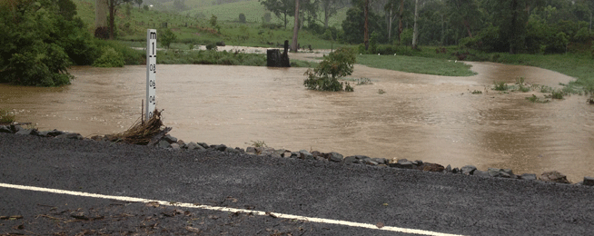
Melbourne’s many bike routes along waterways will become impassable and should not be used.
The Victorian SES website has a local flood information page where you can search flooded areas by council.
Bicycle Network urges bike rider not to attempt to ride or walk through flood water.
The City of Yarra advises “The expected heavy rain will cause flooding along shared trails in Yarra and beyond, from Friday until Monday. Walkers, runners and people riding bikes should avoid using shared paths and not enter flooded paths, or travel beyond access control (flood) gates located at Dights Falls, Hall Reserve, Bundara Street Park.”
Yarra Council will lock access control gates at various locations, around midday Friday December 1. It is expected that gates will be re-opened on Monday 4 December, if conditions allow.
“Council's staff and contractors will make every effort to clear all flood damage by Tuesday 5 December. Path users should expect mud, debris and other hazards along the paths once flooding has subsided, until cleared,” Yarra Council advises.
Flooding will occur at the following locations:
Main Yarra Trail:
- Burnley Harbour, Mary Street, Burnley
- Walmer/Burnley Street to Victoria Street, Abbotsford
- Clarke Street, Abbotsford
- Dights Falls to Johnston Street, Abbotsford
Merri Creek Trail:
- High Street to Heidelberg Road, Clifton Hill & Northcote
- St Georges Road to Sumner Park, North FItzroy and Brunswick East
Flooding is also very likely to occur: along north and south banks of Yarra River at South Yarra, Southbank, Docklands, Jolimont and City; along Moonee Ponds Creek from Parkville to Docklands; and Darebin Creek Trail from Preston to Alphington.
Port Philip council advise seven things residents should do today.
For on-road trips bike riders should expect that traffic will be disrupted in places and delayed. Riders should exercise caution and must follow detour signage and the directions of emergency services staff.
In rain, bike riders must remember that the visibility for motor vehicle drivers will be reduced. Bike riders should turn their lights on and ride with extra caution.
The Age reports that Public Transport Victorian and VicRoads both suggest people take only essential trips.
“Public Transport Victoria is urging customers to avoid using the network if possible and said that it had activated its incident control centre and was working with Emergency Management Victoria and the Bureau of Meteorlogy to avoid disruptions.
“VicRoads is also urging motorists to stay off the roads, but said if travel is essential people should ensure their headlights are on and they do not ride or drive through flood water.”
Read more from The Age.